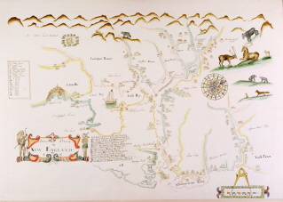
Tracing of Piscataway River in New England (by I.S.) ca. 1665, showing settlement around the Piscataqua including Strawberry Bank. Courtesy of the Baxter Rare Maps Collection, Maine State Archives. Original in the British Library.
A Great Share from blog of Charles B. Doleac, Esq. I added a few pictures into the blog.
TIMELINE OF THE SETTLEMENT AND INCORPORATION OF NEW HAMPSHIRE TOWNS
In 1603, the French king granted a charter to DeMonts for the territory in the "New World" between 40 and 48 degrees North Latitude. In 1606, King James I granted the Virginia charter, in two parts, with North Virginia covering nearly the same ground as the French charter.
In 1623, English settlers established colonies at Dover Point, and Odiorne Point (now Rye) near the mouth of the Piscataqua. Hilton’s Point was first settled in 1628. As a frontier under constant threat from attack by the French and their native allies, garrison houses are evidence of the well-substantiated fear the English had of the Wabanaki. The covert military tactics of the First Nations had already influenced European warfare and fear of those terror tactics was an effective weapon in itself. Some attribute the 1692 Salem Witch hysteria to this environment of paranoia.
On April 20, 1700, the Earl of Bellomont, English royal governor of New England and New York wrote, "If there should be a generall defection of the Indians, the English in a moneth’s time would be forced to take refuge in their Towns where I am most certain they could not subsist two moneths."
As the English settlements pushed deeper into Wabanaki hunting and fishing grounds that the tribes understood the treaties had protected, the First Nations retaliated with attacks: on the settlements in Dover in 1689 and 1694 and on the coastal towns of Maine. By 1703 few English settlements northeast of Wells, Maine remained, except Falmouth. Yet, as historians Tad Baker and John Reid observe, "The unwelcome reality was that native forces were capable of doing irreparable harm to outlying colonial settlements, either English or French, and of striking even inside core areas. Second, the nations themselves consistently pursued strategic objectives ... such as protecting borders and promoting favorable trade agreements. Warfare, for the Wabanakis, was not the preferred method to achieve those goals."
 |
| Gov Dudley |
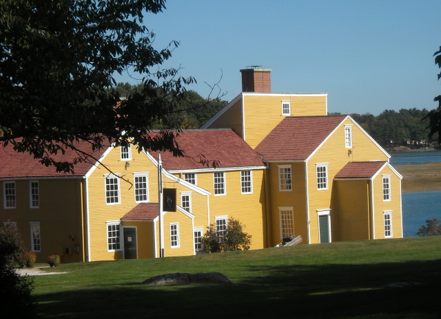
At the meeting in Portsmouth in 1713, Gov. Dudley of Massashuetts referenenced seven previous treaties between the English and the Wabanaki that tried to define expectations on both sides. By this time, the First Nations seem to have conceded the shores of the Piscataqua River -- the Piscataqua themselves and the Squampscott had been the first the suffer the consequences of the epidemic brought to the seacoast aboard European vessels -- while warning the English away from outlying settlements such the Portsmouth Plains (attacked in 1696). The 1713-14 Treaty ushered in a time of peace and prosperity in Portsmouth, exemplified by the MacPhaedris (Warner) House, built in 1716 and other growth that followed.

Main phases for settlement:
1623 The first settlement in New Hampshire, established by David Thompson in 1623 at Odiorne's Point, and named Pannaway.
1629-38 Four original town grants: Dover (1623 called Hilton's Point), Portsmouth (1630 called Piscataqua/Strawbery Banke), Exeter (1638 called Squampscott), Hampton (1638 called Winnacunnet
1728 "Narragansett" townships
Seven Narragansett townships were granted by Massachusetts in 1728 and the years following to veterans of King Phillip's War, also known as the Narragansett War, or to their heirs.

- Narragansett Township No. 1 (now Buxton, Maine)
- Narragansett Township No. 2 (now Westminster, Mass.)
- Narragansett Township No. 3 (now Amherst, N. H.)
- Narragansett Township No. 4 (now Goffstown, N. H.; the land was found unsuitable, and replacement land was subsequently granted in what is now Greenwich, Mass.)
- Narragansett Township No. 5 (now Bedford, N. H.)
- Narragansett Township No. 6 (now Templeton, Mass.)
- Narragansett Township No. 7 (now Gorham, Me.)

Jaffrey is one of three contiguous towns collectively known as the Monadnock townships (the others are Rindge and Dublin) that were laid out in the 1740s, shortly after the boundary line between Massachusetts and New Hampshire was resolved. Each was granted by the Masonian Proprietors, a group of wealthy Portsmouth citizens who operated essentially as a speculative land company and granted many of southern New Hampshire's towns. The recipients of Jaffrey's thirty-five-square miles of primeval forest in 1749 were forty individuals, most of them residents of Dunstable (now Nashua and Hollis). Their new settlement was known variously as "Monadnock No. 2," "Middle Monadnock," or "Middletown."
 |
| Royal Gov Wenworth |
1741 Land grants following end of King George's War and setting of NH-MA border
1760 Land grants by Royal Gov Wentworth following surrender of Canada
In the eighteenth century, Massachusetts granted unappropriated land to the veterans of Sir William Phipps' expedition against French-held Canada in 1690, as compensation for their services. Whole townships were granted to certain military companies, and became known as Canada townships. These were located in the northern extremes of Massachusetts, and in the District of Maine, then part of Massachusetts. Several Canada Townships were found in 1740 to lie within the territory of New Hampshire, and additional land within Maine was conveyed to the disappointed proprietors. Eight Canada townships were granted in south-central New Hampshire—among them, Beverly Canada (now Weare), Rowley Canada (now Rindge), Salem Canada (now Lyndeborough and Wilton) and Ipswich Canada (now New Ipswich).

In 1623, English settlers established colonies at Dover Point, and Odiorne Point (now Rye) near the mouth of the Piscataqua. Hilton's Point was first settled in 1628 (local tradition 1623), and was probably palisaded across the neck.There were up to 50 garrison houses built in and around Old Dover Township (including present-day Somersworth, Rollinsford, Madbury, Durham, and Lee) between 1623 and an attack in 1689 which burned five of the garrisons.
Several of the garrison houses were burned in that attack:
Capt. Peter Coffin's Garrison (built 1650's, fortified 1683 on the south side of the Cocheco River), on Orchard Street near Central Avenue, Tristram Coffin's Garrison, near the old Belknap School.


Major Richard Walderne's (Waldron's) Garrison (built 1664, fortified 1674), on the north-side of the Cocheco River
Richard Otis' Garrison (fortified 1683) on Mt. Vernon Street
Paine's Garrison at Rogers Street and Portland Avenue
Others survived the attack:
Capt. John Heard's (Hurd's) Garrison (built 1660's, fortified 1675) on Central Avenue near Garrison Hill
Capt. John Gerrish's Garrison (built 1670), along the Bellamy (Back) River
Richard Pinkham's Garrison (fortified 1675, dismantled 1825),
Tibbet's Garrison between Pinkham's Garrison and the second Meeting House
Varney's Garrison (unknown date) dismantled 1830's,
Lt. Zachariah Field's Garrison (built 1690 or 1694, fortified 1707) on "Field's Plains",
Meserve's Garrison (unknown date),
Benedictus Torr's Garrison (1700 ?) burned and rebuilt,
Ezekiel Wentworth's Garrison (1700's),
Lt. John (Jonathan) Hayes' Garrison (1707 ?) dismantled 1812.
 |
| William Damme House |
The William Damme Garrison (1675) is the only remaining intact garrison house in Dover. Originally located south of the Bellamy (Back) River near Garrison Road and Spruce Lane. it was moved to the Woodman Institute Museum in 1916. The second Dover Meeting House (1654) on Dover Neck (Nutter Hill) was fortified in 1667 and 1683 with a 100-foot square, eight-foot high stockade around the house. It was demolished by 1695. Site is marked with monument.
Odiorne's Point was the site of the state's first European settlement, Pannaway Plantation (1623 - 1627), which had a blockhouse named the Citadel of Safety, and the first Great House, built by David Thompson. The settlement was abandoned in 1627. The John Odiorne Garrison was built here in 1670.
 |
| Berry Brook Rye NH |


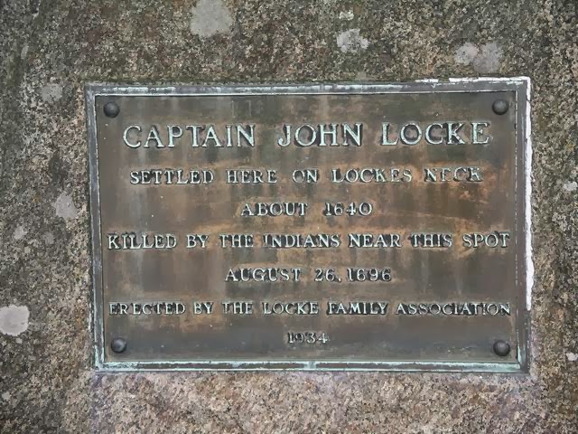

The William Berry Garrison (1649) was located at Sandy Beach on Washington Road. John Locke's Garrison was on Locke's Neck. It was attacked in 1694.
Strawbery Banke, was the original name for Portsmouth from 1630 to 1653. An outer defense fort was excavated in 1803 at the northeast corner of High Street and Market Square, now the Peirce Block. Portsmouth originally included Newington, Rye, New Castle (until 1693), and Greenland. The second Great House (1631 or 1634 - 1685) built by William Chadbourne for the Laconia Company was located on Water (Marcy) and Court Streets. There were at least three other garrison houses: one at the head of Jacob Sheafe's Wharf on Water Street, the John Cutt Garrison on Market and Court Streets, and the Russell Garrison near the "Ferryways." None remain. Elsewhere in town were the Asa Ham Garrison (unknown date) at Bartlett Street on Islington Creek, the Plains Garrison (1690's) which was attacked in 1696, and the Henry Beck Garrison (1664) on the south-side of Sagamore Creek (west of the present-day bridge). Other houses included the Sherburne House (1695) now part of Strawbery Banke Museum.
The site now named Fort Constitution, a New Hampshire State Historic Site, was placed in 1631 and known as The Castle through 1666. From 1692 to 1775, the site was known as Fort (or Castle) William and Mary. The Castle was the site of the July 1713 meeting between the English and the "Eastern Indians."
Fort Star (1653 - 1776, intermittent), Star Island, Isles of Shoals -- A two-gun stone fort built as a defense against Indians and French. The site is west of the present hotel, facing the mainland. Rebuilt with 11 guns and regarrisoned in 1692 for King William's War, and later for Queen Anne's War. Regarrisoned again with nine guns in 1745 for King George's War. In 1776 the fort was dismantled and the settlers removed to the mainland. No remains.
1629 First "NH patent." Division of Gorges-Mason holdings at the Piscataqua River
1629-35 Laconia Company formed (Gorges/Mason) for inland fur trade. Focused on Piscataqua fishery until bankruptcy in 1635
1631 Stratham ("Winnicutt") established (incorporated 1716)
 |
| Rev John Wheelwright |
Edward Sewell's Garrison (1676), located on Epping Road, has been greatly altered over time. A town fort, the Great Fort, was located near the Meeting House (1695).
Hampton was founded in 1638, and included present-day North Hampton, Hampton Falls, Seabrook, South Hampton, Kensington, East Kingston, and Kingston Hampton Falls Garrison Houses -- Bonus Norton's Garrison (1700's) was located near the Hampton causeway on Lafayette Blvd. James Prescott's Garrison (1668 ?) (aka Prescott's Fort) was on Applecrest Farm. Daniel Tilton's Garrison (1667) was on Monument Square.
Hampton Garrison Houses -- Thomas Philbrick's Garrison (before 1647 known as William Sanborn's Garrison) was torn down in 1855. Col. Joshua Wingate's Garrison (1700), later known as Edmund Toppan's Garrison, was located near Whittier's Corner, and demolished in 1900. The Hampton Meeting House was palisaded in 1689 following the attacks in Dover. It was enlarged in 1692 to allow room for small houses within the palisade. John Dearborn's Garrison (1690's) in North Hampton was a settlers' garrison house located near the village green and the first town Meeting House (1734). Later known as Simon Dearborn's Garrison (1720's).
1638 Settlement of Greenland as parish of Portsmouth (incorporated 1704)
Greenland Garrison Houses -- Capt. Walter Neale's Garrison (1660's) was located on Heard's Neck near the mouth of the Winnicut River. It was the only recorded garrison house in town. The Samuel Weeks' House (1638; rebuilt 1710), still standing, originally may have been another garrison house.
The Weeks House in Greenland NH.
1639 North Hampton settled
1641-43 Absorption of Dover and Portsmouth by Massachusetts for strategic value of Piscataqua River given Anglo-Dutch tensions (war 1652-54) and English Wabanaki tensions in Maine.
1643 Absorption of Exeter by Massachusetts
1659 Penacook (later Concord) settled
Concord Garrison Houses -- A town fort named Irish Fort (1725 - 1726) (or Penacook Fort 2) was at the old Penacook settlement, later renamed Rumford, then Concord. It was an outpost of Londonderry. A Penacook Indian fort was located on the east bank of the Merrimack River, probably on Sugar Ball Bluff. Col. Richard Waldron's Trading Post (1667 - 1668), East Concord was located on the east side of the Merrimack River at or near the Penacook Indian village.
1664 Jackson House (Portsmouth NH) built.
1665 Merrimack NH settled (established 1722)
1666- The King's Commissioners order a fort to be built at Fort Point, New Castle, over the objections of the Mass Gen. Court. 1697: New Castle (NH) chartered as parish of Portsmouth
1669 Durham created as a parish of Dover (incorporated 1732) known as Oyster River Plantation until 1732.
Durham Garrison Houses -- There were 12 active garrison houses with 20 militia soldiers posted within at the time of the 1694 "Oyster River Massacre." Four were destroyed:
Francis Drew's Garrison (1640's ) at Drew's Point
Thomas Edgerly's Garrison north of Meader's Creek
John Meader's Garrison (1660's) on Hill's Neck
Charles Adams' Garrison
Others survived:
William Beard's Garrison (also attacked in 1675) on Beard's Creek,
Lt. James (John) Davis' Garrison (1654) at the mouth of the Oyster River on Wagon Hill Farm (also survived 1689 attack),
Thomas Bickford's Garrison palisaded, on Durham Point,
James Bunker's Garrison (1650's) near Bunker's Creek (also survived 1689 attack)
Robert Burnham's Garrison
Stephen Jones' Garrison (1672) on Jones' Creek
John Goddard's Garrison (1630's)
Valentine Hill's Garrison (built 1649), now incorporated into the Three Chimneys Inn,
Mathes' (Matthews') Garrison (survived 1694 attack),
Smith's Garrison (survived 1689 attack),
Capt. John Woodman's Garrison (1656 ) at the head of Beard's Creek (survived 1694 attack), burned in 1896, John Rand's Garrison and William Durgin's Garrison were built in 1695. Others included: Jonathan Chesley's Garrison (1716 ), Capt. Samuel Chesley's Garrison (1700 ), Philip Chesley's Garrison (1700 ), Joseph Chesley's Garrison (1707), George Chesley's Garrison (1699 ), David Davis' Garrison (2) (1720's ) at Packer's Falls (moved in 1790), Jabez Davis' Garrison (unknown date) one mile from the town, the Pendergast Garrison (1737) near Packer's Falls,, and James Tilley's Garrison (1710's) near Packer's Falls.
In the 1690's, Newmarket -- Several garrison houses were located here, including the David Davis Garrison (1) (1695) on Lubberland Road. It was attacked in 1696, and was renamed Capt. John Smith's Garrison (1696). It was demolished in 1880. On the Lamprey River was Doe's Garrison (1650), which still existed when photographed by HABS in 1937.
1671 Congregational church gathered in Portsmouth under Joshua Moody
1680 Establishment of the royal province of New Hampshire
1680 Settlement at landing on Salmon River (later Rochester)
1681 Settlement at Newfields (part of Exeter)

Newfields Garrison Houses -- Capt. William Hilton's Garrison (1680), on Fowler's Hill, was a palisaded log house with a sentry box on the barn. Attacked in 1690. Demolished in 1822. Col. Edward Hilton's Garrison was attacked in 1706, It was later known as Col. Winthrop Hilton's Garrison. Aaron Rollins' Garrison was attacked in 1723, located near the lower falls of the Piscassic River. There was once another garrison house on the old Hall's Mill Road. The Hilton Family cemetery is located in Newfields. The Thyng Family cemetery is located on the Newfields/Exeter town line.
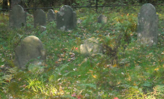
The Hilton family cemetery in Newfields NH.
1689 Overthrow of Dominion of New England; temp return of NH to MA jurisdiction
1689-97 King William's War (War of the League of Augsburg)
1690 Lyndeborough established as "Salem-Canada"
1690 Newington established as "Bloody Point"
Newington Garrison Houses -- Anthony Nutter's Garrison (1663) was at Welshman's Cove. Nicholas Harrison's Garrison was on Fox (Bloody) Point, renamed John Downing's Garrison in 1707. Lt. William Furber's Garrison (1690's) was at Welch Cove. John Dam's Garrison (1690's) was also at Welch Cove. Newington was known as Bloody Point until 1714.
1691 New Massachusetts provincial charter including all of Maine and Nova Scotia
1692 Re-establishment of royal government in NH
1694 Kingston established (5th NH town) – peace treaty w/Indians following King William's War
Kingston Garrison Houses (1700's), Kingston
Aaron Sleeper's Garrison (1700) was on Exeter Road. Tristram Sanborn's Garrison was west of Sleeper's.
1702 Accession of Queen Anne
1702-11 Queen Anne's War (War of the Spanish Succession)
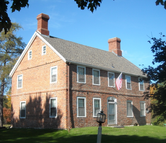
1704 Greenland incorporated and Leonard Weeks constructs brick house (extant) 1709 James Stackpole's or the Sligo Garrison (1709 ?) was on Sligo Road at "The Point". Rollinsford, once known as Salmon Falls, was seperated from Somersworth in 1849.
1709 Gilman Garrison House built in Exeter, NH
 |
| Gilmam Garrison |
1712 Meeting house (extant) built in Newington, NH
1713 Chester Wood (later Hooksett) established
1717 Addison (later Marlborough, chartered 1761) established
1718 Sayward-Wheeler House built in York Harbor, ME
1722 Rochester established -- There were five blockhouses built in 1744 at town expense, three on the road to Norway Plains (unnamed), Squamanagonic Blockhouse at Squamanagonic (present-day Gonic), and Newichawannock Blockhouse at the Newichawannock River (Salmon Falls River). There were several other private garrison houses in the area. Copp's Garrison, Goodwin's Garrison, Rawlins' Garrison, the Rev. Amos Main Garrison on Rochester Hill, and Richard Wentworth's Garrison were a few of the private garrison houses.
 |
| Ossipee Town Center |
1725 Indian fort at "Wigwam Village" destroyed, rebuilt by English and town named Ossipee. Abenaki Fort (1650's - 1676), Center Ossipee-- An Abenaki one-acre log palisade built by British labor for protection against the Mohawks. It was destroyed by the colonial militia during King Philip's War. The site, owned by the Ossipee Historical Society, is at the Indian Mound Golf Club at Ossipee Lake.Capt. John Lovewell's Fort (1722 - 1725), Center Ossipee -- A colonial militia fort. Weirs Blockhouse (1736), Weirs Beach A 14-foot square log blockhouse. This area was once a part of Gilmanton.Fort Winnipesaukee (1722), East Alton. A colonial militia fort was proposed for Fort Point on Alton Bay. It was to be 100 feet square, with two or four 14-foot square blockhouses at the corners. It was probably never built, due to lack of funds.
Derry Located in Derry Village and East Derry, which was once a part of old Londonderry Township, were Capt. James Gregg's Garrison, Samuel Barr's Garrison, and a few other garrison houses. A blockhouse was built next to the East Parish parsonage.
1726 Rye incorporated as parish of New Castle

1727 Nottingham-- A town blockhouse on the North River. It was attacked by Indians in 1747 and the defenders killed. A stone marker (1936) is on NH 152. (There is a "Fort Hill" northeast of town.)
1727 Settlement of Canterbury
1728 Settlement of Narragansett forts No. 3 (Amherst): Amherst Garrison Houses -- (1750's), Amherst There were seven garrison houses recorded in this area during 1753, as well as a town blockhouse. The town was never attacked by Indians. Amherst was originally known as Souhegan West.Milford Garrison Houses (1747), Milford--William Peabody's Garrison was located on the north-side of the Souhegan River (possibly located in Amherst), and William Colburn's Garrison was located in East Milford north of Long Pond. Milford was originally known as Monson. No. 4 (Goffstown) No. 5 (Bedford) : Bedford Garrison Houses -- Located here were Capt. John Goffe's Garrison (1745) opposite Cohas Brook at Goff's Falls, Robert Walker's Garrison, and two other unnamed garrison houses. Bedford was originally known as Souhegan. Pembroke (No. ?) -- James Moore's Garrison (built 1730, fortified later) was said to be the first framed house built in the area. Rev. Aaron Whittemore's Garrison (1737 ?) was located south of the cemetery on Pembroke Street.
1733 Settlement of Arlington (later Winchester)
(1744 - 1745 or 1746), Winchester The town was attacked by Indians in 1745 or 1746, then abandoned until 1753. Most of the settlers' homes were palisaded, including Josiah Willard's Fort and Alexander's Fort.
1735 Settlement of Starkstown, Alstead, Gorhamtown, Piscataquog (later New Boston), Bakerstown (later Salisbury), New Ipswich
1735-36 Monadnock No. 1 (Mason), No. 2 (Jaffrey/Rindge/Dublin/Wilton/ Westmoreland) -- (1730's, 1740's), Westmoreland-- Great Meadows Fort (1730's), a square log blockhouse also known as Fort at Number Two Township. Also nearby was Daniel How's Fort (1740's). No. 3 (Arlington). No. 4 (Charlestown) -- Fort at Number 4 (1744 - 1760), Charlestown. A reconstruction of the fortified settlement known as Number Four Township, located on the Connecticut River. Also known as Fort Stephens in 1747 after Lt. Phineas Stephens. Attacked by the French in 1747. The settlement was named Charlestown in 1753. Used again during the American Revolution, it served as a staging point for Patriots heading to Bennington, Vermont in 1777. No. 5 (Hopkinton/Roxbury), No. 6 (Henniker/Nelson), No. 7(Hillsborough/ Orford), No. 8 (Washington)

1736 Walpole settled: A large L-shaped log house, built in 1752, that was palisaded and armed with one gun. Another fort was built nearby along the Connecticut River to protect settlers going back and forth to North (Upper) Westminster, Vermont. This area was once Number Three Township. John Kilbourn Garrison (1749 - 1755), Walpole a palisaded settlers' home located about one-third mile south of the Cold River. It was attacked in 1755. Site marked with granite monument.
1736-47 Keene. Fort Keene (1736 or 1738 - 1747), A double-stockaded town fort that was 90 feet square, with 20 barracks and two wells. The town was attacked and burned by Indians in 1746. The settlers holed up in the fort for one year then abandoned the area, not returning until 1750 - 1752. Site located at 300 Main Street. The town was previously named Upper Ashuelot.Swanzey Garrison Houses -- (1738 - 1747), Swanzey-- Capt. Nathaniel Hammond's Garrison was palisaded, as was John Evan's Garrison (1). There was also Meeting-House Hill Fort. The town was abandoned in 1747 after several Indian attacks.
1736-49 Land grants to soldiers returning from Canada: Rowley-Canada (Rindge), Sylvester-Canada (Richmond), Salem-Canada, Beverly-Canada (Weare)
1737 Hooksett. A settlers' garrison house built.
1740-48 King George's War (War of the Austrian Succession)
1741 Settlement of MA-NH boundary and appt of Benning Wentworth as Governor of NH
Royal Governor Benning Wentworth's home in Portsmouth.
1741-49 Towns chartered by Wentworth: Atkinson,
Brentwood: -- Stephen Dudley's Garrison (1684), torn down before 1835, undetermined location. Henry Marshall's Garrison (1705) at Marshall's Corner, Nicholas Dudley's Garrison (1720 ?) (son of Stephen) near Deer Hill, and William Graves' Garrison (1720's), demolished 1860's. Brentwood was seperated from Exeter in 1742.
Canterbury (est 1727), Dublin (Monadnock), Dunbarton (Starkstown est 1735), Effingham,
Epping (MA charter): (1740's ?) -- David Lawrence's Garrison was located by the railroad bridge. Richard Sanborn's Garrison was located at Red Oak Hill. There was a third garrison house elsewhere (undetermined location). None exist today.
Goffstown, Grantham, Hale's Location, Hampstead,

Hillsborough (1735) -- Hinsdale Garrison Houses -- Fort Hinsdale (1742) a blockhouse built on Ash Swamp Brook near Oak Hill to compliment Fort Dummer just across the river in Vermont. Also known as the Rev. Ebenezer Hinsdale Garrison (also spelled Hinsdell). Daniel Shattuck's Garrison (built 1736, fortified 1741 - 1748) (aka Fort Shattuck), was also located on Ash Swamp Brook. It was fortified by connecting it with a palisade to an identical structure on the other side of Ash Swamp Brook. John Evans' Garrison (2) (built 1741, fortified 1754) was located south of the Ashuelot River. Robert Cooper's Garrison (1737) was located near the Hinsdale Meeting House. Hinsdale Indian Fort An Indian fort was located on a hill by the Connecticut River, with a deep trench extending to the river.
Hollis: (1740's), West Hollis-- A settlers' garrison house built in 1732, later fortified.
Hudson, -- Hills' Garrison (1710) built by either Nathaniel Hills or Henry Hills. Site marked with stone monument. Joseph Blodgett's Garrison (1710's) was located about 2.5 miles south of the mouth of the Nashua River. Site marked with stone monument. John Taylor's Garrison was between Derry Road (NH 102) and Litchfield Road (NH 3A), about one-half mile south of the Hills Garrison. Capt. Robert Fletcher's Garrison (unknown date) once stood at the state line along the Merrimack River. Hudson and Pelham were known as Nottingham West in 1733, previously part of Dunstable (Nashua).
Jaffrey (Monadnock No. 2), Mason (No. 1),
Merrimack (1665, settled 1722): A trading post for the Indian trade. The Penecook Indian village Naticook was here.
Middleton
Nashua (Dunstable): Nashua Garrison Houses -- The Cummings Garrison was located east of the Daniel Webster Highway and south of Split Brook. The Galusha Garrison was east of the railroad at the state line. The Harwood Garrison was south of (?) Brook along the Merrimack River. The Thomas Lund Garrison was east of the Daniel Webster Highway on the north-side of (?) Brook. The Queens Garrison was on Bowers Street. The John Solendine Garrison was near the Lund Garrison, possibly near Salmon Brook. The Rev. Thomas Weld Garrison was in South Nashua. The Whiting Garrison was on Robinson Road east of Salmon Brook. Nashua was originally known as Dunstable. The town was attacked by Indians in 1702. (1653 - unknown), Nashua-- A trading post for the Indian trade. The Penecook Indian village Wataunick was here.

New Durham (Cocheco), Newton, North Hampton (1639), Pelham, Plaistow, Rindge (Monadnock No. 1), Salem (1736),
Sanbornton (1746 - 1747), Sanbornton-- A six-walled colonial militia fort west of Winnisquam and north of East Tilton, on the north shore of Little Bay. The fort's stone blocks were later removed to build a dam on the lake.
South Hampton, Sutton, Tuftonboro, Warren, Wilton (No. 2, 1730s), Winchester (Arlington 1733), Windham
1746-48 Lt. Archibald Stark's Fort Manchester -- A 125-foot square stockaded fort and blockhouse located on Baker Brook, on the northwest side of Nutt's Pond, in present-day Precourt Park. Built for the protection of the settlers of both Goff's Falls (Moore's Settlement) and Amoskeag Falls (Manchester). Site was marked in 1929. Foster's Garrison (1746) was located near Amoskeag Falls.
1749 Cocheco established (later New Durham)
1750 Peterborough Slip established (later Temple)
1751 Holderness settled
1753 Grenville established (later Newport)
1753 Buckingham established (later Unity)
1755 Madbury established-- Abraham Clark's Garrison (1693) demolished 1836, David Daniel's Garrison on David's Lane, Eli DeMerritt's Garrison (1720) demolished 1836, located near Pudding Hill, Capt. Paul Gerrish's Garrison, Daniel Meserve Jr.'s Garrison in Freetown on Harvey's Hill, William Tasker's Garrison (built 1693, fortified after 1694 Indian attack) on Moharimet's Hill, demolished 1820 ?, and William Twombly's Garrison (1730's) demolished 1842.
1760 Surrender of Canada/Accession of George III
1761-65 129 towns chartered by Royal Gov Benning Wentworth: Acworth, Albany, Alstead (1735), Amherst (Narragansett No. 3, 1728), Atkinson, Bath, Benton, Boscawan, Brookline, Campton, Canaan, Candia, Chatham, Colebrook, Columbia, Concord (Penacook, 1659), Conway, Cornish, Croyden, Dalton (Chiswick), Danville, Deerfield: (1743), Deerfield A settlers' garrison house once located south of town. Site is marked.
Dorchester, Dunbarton (Gorhamtown 1735), Eaton, Ellsworth, Enfield, Franconia (Indian Head), Fremont, Gilsum (1752), Goffstown (Narragansett No. 4), Goshen, Grafton, Grantham, Groton (Cockermouth), Hancock, Hanover, Harrisville, Haverhill (Lower Coos), Henniker (No. 6), Hillsborough (No. 7 1735), Holderness (1751),

Hooksett (Chester Wood, 1713): Chester Garrison Houses -- Benjamin Hills' Garrison (unknown date and location), and Major John Tolford's Garrison (1724) on Walnut Hill Road, torn down in 1883.
Hopkinton (No. 5, 1735): Hopkinton Garrison Houses -- Aaron Kimball's Garrison (1730's) was on Hopkinton Road east of town. Putney's Garrison (unknown date) was built by Samuel and John Putney on Putney's Hill west of town. Site is marked by stone tablet. David Woodwell's Garrison (unknown date) was located one-half mile east of Contoocook on NH 103. Site is marked.
Jaffrey (1736, Monadnock No. 2 1749), Jefferson, Lancaster, Landaff, Lebanon,
Lee: -- There were garrison houses here during the 1680's. Also here was Capt. Nathaniel Randall's Garrison (1720's, demolished 1850), Joseph Doe's Garrison (1737), later renamed Elijah Fox's Garrison (demolished 1880), and the Jones' Garrison (1700) in Newtown.
Lempster, Lincoln, Lisbon, Lyman, Lyme,
Lyndeborough (Salem-Canada 1690), Lyndeborough Garrison (1740's) A town garrison or blockhouse was here for the protection of the settlers of Salem-Canada, the original name of the settlement.
Madbury (1755), Marlow (Addison, 1717), Mason (No. 1, 1741), Meredith (New Salem "Masonian" 1743), Moultonborough, Nelson (Monadnock, No. 6), New Hampton, New Boston (Piscataquog 1736), New Durham (Cocheco 1749), Newington (Bloody Point 1690s meeting house 1712), New Ipswich (1735), Newport (Grenville 1753), Northumberland (Stonington), Northwood, Orange (Cardigan), Orford (No. 7 , 1735),

Peterborough: (1750's)-- A town fort or blockhouse was probably built here, garrisoned by 15 to 20 men, to protect the then-frontier settlement. The town was attacked by Indians in 1750, with the fort built afterwards.
Piermont, Plainfield, Raymond, Rindge (Monadnock No. 1, Rowley-Canada 1749), Rumney, Salisbury (Bakerstown 1736), Sandwich,
Seabrook (1638 part of Hampton): -- Gove's Garrison (1703) was located near present-day Lafayette and New Zealand Roads. It no longer exists. Others may have also existed. Seabrook was once a part of Hampton, then Hampton Falls, until 1768.
Shelburne, Springfield (Protectworth),
Stratford: Stratford Fort (1768, 1775), Stratford -- The first Indian trading post on the northern frontier was established here in 1768. Site is marked. A settlers' log fort was built nearby in 1775.
Surrey, Tamworth, Temple (Peterborough Slip 1750), Thornton, Unity (Buckingham 1753)
No comments:
Post a Comment